
Page 56 - Michigan City, IN US Highway 421 Corridor Plan
P. 56
3.3 Corridor Redevelopment Goals, Principles and Strategies
Goal 3.3.3: Synchronize Land Development 9. Review the City’s Capital Improvement Program (CIP) for 2. Mostly on-street parking and minimal surface parking (until
Regulations with Planning Policies (ULI) infrastructure projects within the 421 Gateway District the urban character begins to give way to typical site design Modernize the Area.
to determine whether the scope of any project may
oriented more toward the automobile).
Strategies be amended in order to advance the development of
the proposed comprehensive access road program, as 3. One of the few commercial districts where structured “Walkability, livability, get rid of
delineated in Figure 4.1, Access Road Plan. parking may be financially viable. ‘big box’ mentality and aesthetics.
A. Revise Michigan City Land Development 4. Multi-story, mixed-use structures are encouraged. Create parks and greenspaces.”
Regulations to promote the scale and B. Amend the Michigan City Appendix C,
character of proposed development and Joint Zoning Ordinance, Article 7. Business 5. Conducive for pedestrian activity and interaction, with public
plazas and pocket parks providing green space amidst
redevelopment options within the 421 Districts, to include an Urban Commercial/ an urban environment, and a place to gather and host
Gateway District, as outlined within Section Mixed-Use (B4) District. community events.
5.2, Land Development Guidelines. The proposed Urban Commercial / Mixed-Use (B4) District 6. Streetscape enhancements in public rights-of-way are
retains the fabric, character, design and densities of a traditional emphasized given limited area for private landscaping
Actions and Initiatives “downtown” central business district. This urban environment is relative to other character areas.
characterized by taller, larger buildings that occupy most if not all
1. Integrate public facilities into the 421 Gateway District’s of the site and are set at the street edge with parking largely on-
redevelopment strategy. Public facilities should be sited street and in structures, with reduced common surface parking 7. Public/institutional uses designed to match urban character.
in ways that help leverage private investment and provide
a convenient destination where residents can accomplish lots. Transportation corridors are scaled for pedestrian rather C. Within the Michigan City Appendix C, Joint
multiple tasks, and help shape a more rational development than automobile use. Sidewalks are wide enough to contain Zoning Ordinance, amend provisions of Light
pattern. seating areas for outdoor cafes. Any original buildings with
historic or design significance have been mostly well-preserved. Industrial District (M1), Section 09.03, Lot Area
2. Zoning must be clearly linked to the public’s implementation Permitted uses would include: and Width Requirements, to enable minimal
plans, including effective by-right development standards as — Mixed-use (on single sites and within individual structures); building setbacks (0-5 ft) for commercial uses.
well as transfer of development rights in mature strips.
— Residential above commercial or office;
3. Scale retail-zoned land to reflect a realistic assessment of — Live/work units;
the size, strength, and character of the market.
— Attached and multi-family `residential;
4. Structure zoning within development nodes to encourage — Commercial retail/services;
denser forms of development that can be reached by
multiple modes of transportation. — Office;
— Public / institutional;
5. Provide regulatory options that facilitate parceling and land
assembly to accommodate recommended changes in land — Places of worship;
use configurations. This may involve changes that eliminate — Entertainment;
setbacks, provide streetfront and midblock development
on multiple sites, or combine separately-owned parcels to — Parking structures and on-street public or commercial
create new development options. parking areas (surface parking lots may be considered as a
limited use); and
6. Set Parcel Size Standards. Adopt zoning regulations that
set a minimum parcel size along the strip so as to constrain — Parks and public spaces.
curb cuts and encourage more coordinated development As illustrated in Section 5.2, Land Development Guidelines,
and fewer stand-alone stores.
district characteristics would include the following provisions:
7. Prevent “deadening” uses, such as mini-storage facilities,
from dominating the 421 Gateway District. 1. Greatest site coverage. Streets and other public spaces
framed by buildings with zero/minimal front setbacks,
8. Stimulate infill, new forms of mixed-use, and pedestrian- creating “architectural enclosure” versus the progressively
oriented retail development on remaining retail-zoned land. more open feel in areas that are more suburban in density
and character.
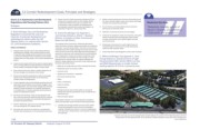
In general, land uses, such as this storage facility along US Highway 20, just east of the Project Study Area, should be
avoided within the 421 Gateway District, as the use tends to deaden pedestrian activity within the immediate area.
3-06 Source: Google Earth
3.0 Envision 421 Gateway District Adopted: August 16, 2016