
Page 28 - Michigan City, IN US Highway 421 Corridor Plan
P. 28
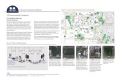
2.3 Environmental Conditions                                                       Figure 2.7  Major Palustrine Wetlands within the Study Area


              2.3 Environmental Conditions

                                                                                                                                        5
              2.3.1 Wetlands within the                                                                                                                                        3                          1
              Corridor Study Area
              There are several wetlands existing within the study corridor,   following four characteristics: (1) area less than 8 hectares (20
              see Figure 2.7, Major Palustrine Wetlands within the Study   acres); (2) active wave-formed or bedrock shoreline features
              Area. There are 119.32 acres all together (taken from the   lacking; (3) water depth in the deepest part of basin less than 2
              National Wetland Inventory Map, compiled by the US Fish   meters at low water; and (4) salinity due to ocean-derived salts
              and Wildlife Service).  (Note: while the information shown and   less than 0.5 percent. Of the several Palustrine wetlands of
              discussed herein is presumed to be accurate, it has not been   varying classifications within the 421 Corridor Study Area, there                                        4
              field verified and therefore cannot be used in place of on-site   are four sizeable wetlands described in the figure to the right.
              wetland delineation.)
                                                                     The Michigan City Redevelopment Commission (RDC) sponsored
              Palustrine wetlands systems, illustrated in Figure 2.8, Palustrine   the preparation of a study for the wetlands at the south
              Wetland Diagram, include all nontidal wetlands dominated   extension of E. Frontage Road entitled The Town Center Road
              by trees, shrubs, persistent emergents, emergent mosses or   Extension (Beam, Longest and Neff, LLC).
              lichens, and all such wetlands that occur in tidal areas where                                                                                   2
              salinity due to ocean-derived salts is below 0.5 percent. See   There are no IDNR Floodplains within the 421 Corridor Study
              Palustrine Wetland Diagram below. Palustrine systems also   Area, however, there are a few floodplains located just outside
              include wetlands lacking such vegetation, but with all of the   of the Study Area, west of and along Ohio Street.


              Figure 2.8  Palustrine Wetlands Diagram

                                                                                                                             1                          2                          3                          4
                                                                                                                                         Cleveland Ave.


                        scrub/shrub    forested         scrub/shrub  aquatic  emergent
                                                                          emergent                                                                                            20
                                             emergent       unconsolidated                                                                                                                            20
                                                                          wetland
                                                                                                                                                                                       Cleveland Ave.
                                                                                                         S. Franklin St.                                                                                                 421
                                                                                                                                 W 400 N
                                                                                                                                                              421
                       f
                                                                                                  The first wetland is located at   The second wetland is near the   The third location is south of   The fourth is located south   The fifth wetland is located
               ‘a’  temporarily flooded                                                           the north end of the 421 Corridor  southeast corner of the 421   US Highway 20 and west of   of US Highway 20 and east of   north of Interstate 94, south
               ‘b’  seasonally flooded   a        a     a                            high water
               ‘c’  semipermanently flooded   b           b  c                       average water  Study Area west of S. Franklin   Corridor Study Area near the   US Highway 421, just west of   US Highway 421, southeast   of CR 400 N, and west of US
               ‘d’  intermittently flooded                     d  e        2m        low water    Street between Southwood Drive   intersection of CR 400 N and   the Lake Plaza Development   of Advance Auto Parts, and   Highway 421.
               ‘e’  permanently flooded                                                           and St. Johns Road and contains   Cleveland Avenue and contains   and contains 0.38 acres of   contains 1.33 acres of emergent
                                                                                                  23.09 acres of forested wetland.  45.95 acres of forested wetland.   swamp wetland and 8.48 acres   wetland and 3.13 acres of
                 Source: USGS Northern Prairie Wildlife Research Center                                                                                 of palustrine system class   aquatic bed-semi permanently
                                                                                                                                                        emergent, subclass persistent   flooded wetland (pond).  The
                                                                                                                                                        water regime saturated wetland.    pond may offer opportunities
                                                                                                                                                                                    for aesthetic and recreational
                                                                                                                                                                                    enhancements.
              2-08

              2.0  Background and Existing Conditions          Adopted: August 16, 2016