
Page 29 - Michigan City, IN US Highway 421 Corridor Plan
P. 29
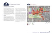
2.4 Existing Land Use Conditions                                                                Figure 2.9  Existing Land Use


                 2.4 Existing Land Use Conditions                                                                                                       W 400 N (Kieffer Rd)

                                                                                                                                                                                             20
                 2.4.1 Built Environment                                                                                                                        Ohio St.                                Ohio St.
                 The 421 Corridor Study Area consists of over 1,300 acres of   Study Area, 203 parcels (36.6 percent / 482.6 acres) is
                 developed and undeveloped parcels. As mentioned, the 421   composed of commercial / retail uses; 38 parcels (9.1 percent                Southwind Dr.
                 Corridor passes through multiple jurisdictions. From Interstate   / 119.9 acres) is composed of professional office / institutional          Westwind Dr.                                                          Coolspring Ave.
                 94 (I-94) to CR 400 N the corridor is within the jurisdiction of   uses; 1 parcel (1.1 percent / 14.2 acres) is composed of light
                 LaPorte County. North of CR 400 N the corridor is within the   industrial uses; and 62 parcels (6 percent / 78.6 acres) is                                                             St. John Rd.
                 Michigan City limits. US Highway 421, south of US Highway   residential use of varying densities.
                 20, is under the jurisdiction of the Indiana Department of                                                                 421                                                  S. Franklin St.
                 Transportation. North of US Highway 20, the thoroughfare   The character of the undeveloped land is either agricultural
                 becomes S. Franklin Street and is under the jurisdiction of the   open space with vegetation confined to along fence lines or
                 City of Michigan City. The parallel thoroughfares to US Highway   other types of boundaries, or it is heavily-forested wetlands or                    Larkspur Ln.  Meijer Dr.
                 421, Cleveland Avenue to the east, and Ohio Street to the west,   lands containing small ponds. Developed land within the 421
                 are both within the Michigan City limits.              Corridor Study Area is predominantly auto-urban in character,   94
                                                                        and possesses all of the elements common to commercial                                                                                  Barker Rd.          Coolspring Ave.
                 Land Use                                               strip development anywhere else in the country. Indeed, strip
                                                                        commercial development in its post-World War II form has been      CR 950 W             Cleveland Ave.                           Cleveland Ave.
                 The lands within the 421 Corridor Study Area vary in use   one of the most common patterns for new stores, restaurants,
                 and utility from vacant, undeveloped lands and lands with   and service businesses; and the US Highway 421 / S. Franklin               W 400 N (Kieffer Rd)
                 environmental constraints (e.g., surface water and wetlands)   Street Corridor and its perpendicular counterpart, US Highway
                 to lands that are currently in agricultural production. The   20, are no different. Despite the prevalence of this pattern of
                 remainder of the lands within the 421 Corridor Study Area   land use, it is widely agreed that strip commercial development
                 have been fully developed to suit a range of services-oriented,   can degrade the overall character of a community’s built                                                  Pahs Rd.
                 programmatic uses. These include multiple forms of commercial   environment, as a result of its visual impacts, its impact on
                 and retail uses, professional office and institutional uses, light   adjoining neighborhoods, and its congestion-inducing effects.                   Woodland Ave.
                 industrial uses and residential uses, as depicted in Figure 2.9,
                 Existing Land Use. Of the 393 parcels within the 421 Corridor   Refer to Figure 2.10, Corridor Segment Descriptions, for a                                        La Porte County  Michigan City  20
                                                                        location map, summary, and images of different sections of the
                                                                        421 Corridor Study Area.
                                                                                                                                   Single Family Residential  Light Industrial                                   0     1000   2000
                                                                                                                                   Multi-family Residential  Parks
                                                                                                                                   Institutional / Civic  Open Space
                                                                                                                                   Commercial            Agriculture
                                                                                                                                   Office


                                                                                                                                                                                                                                   2-09

                                                                                                                                                        Adopted: August 16, 2016          Background and Existing Conditions  2.0