
Page 23 - Littleton, CO Comprehensive Plan
P. 23
15
LAND USE AND COMMUNITY CHARACTER
The City of Littleton must plan effectively for future development and redevelopment, and for ongoing stewardship of
areas intended to remain much as they are. Sound land use planning is essential to ensuring that the City is prepared to
serve anticipated public infrastructure and service needs, and also to create and maintain desired community character.
Land use considerations are integrated with all other Plan components. For instance, the transportation network provides
access to land, which, along with real estate market factors, influences the type and intensity of development that may
occur. The capacity and condition of public utilities can dictate the location, amount, and timing of development, as can
economic development efforts by the City and other partners. Similarly, proximity to parks and public facilities promotes
public health and safety and affects the development potential of an area. Development character and site design shape
community aesthetics and the perceptions held by area residents, tourists, and those considering investment in Littleton.
FUTURE LAND USE AND CHARACTER
Shown on Map 1, Future Land Use and Character, is the general pattern of uses anticipated and/or desired in the years
ahead, and the character contexts in which uses occur. The map, along with the text descriptions in this section, indicate
the use that is expected to predominate in areas where land is undeveloped or, in previously developed areas, based on
what is already on the ground and will likely remain or possibly evolve. Such transitions in use can occur through
redevelopment of previously built sites, “infill” construction on a vacant parcel amid existing built sites, or repurposing of
an existing structure for another use without significant site changes.
Along with the predominant use types, other complementary uses will also remain or may emerge in particular areas
of the city (e.g., small-scale, neighborhood-oriented retail and service uses near the edges of largely residential areas).
Certain uses can be located amid other predominant use types, such as public facilities and places of worship within
predominantly residential areas. Mixing uses on sites is common in downtowns (e.g., upper floor office or residential
above ground-floor retail) and may occur elsewhere in a community as the market accommodates and zoning allows.
Some uses are highly market-driven, with their timing and particular location dictated by the extent and pace of other
types of development. This includes the typical pattern of retail uses locating near new residential “rooftops” and often
at key roadway intersections. The location and extent of various forms of residential development can also be difficult to
predict amid broader housing market cycles and regional needs, combined with developer areas of expertise and interest
in bringing single-family or multi-family products to market.
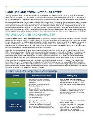
Future Land Use Map versus Zoning Map
Aspect Future Land Use Map Zoning Map
Outlook for future use of land and Basis for applying different land use
character of particular areas of the regulations and development standards in
PURPOSE community. different areas of the community (“zones”).
Macro level, showing generalized Micro level, with an area- and site-specific
development patterns. focus.
Guidance for City’s zoning map and Regulating development as it is proposed,
related decisions (zone change requests, or as sites are positioned for the future
variance applications, etc.) with appropriate zoning (by the property
USE Baseline for monitoring consistency owner or the City).
of actions and decisions with the
Comprehensive Plan.
Existing land use in the city. Comprehensive Plan and future land use
The locational aspects of community map for general guidance.
INPUTS AND planning priorities involving housing, Zoning decisions that differ substantially
CONSIDERATIONS economic development, infrastructure, from the general development pattern
parks and recreation, public facilities, etc. depicted on the future land use map will
indicate the need for some map
adjustments during the next plan update.
Adopted October 15, 2019